 ✨ AI Generated
Yuragawa Railway Bridge
Japanese: 由良川橋梁
Miyazu, Kyoto
This information was written by AI and may contain mistakes. Please check official sources for opening hours, fees, and other details before you go.
Found a mistake? Let us know with “✏️ Something's wrong” on this spot's screen in asobot →
🎧 Audio guide(0:58)
In short
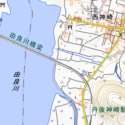
A railway bridge on the Kyoto Tango Railway Miyamai Line that spans the mouth of the Yura River, located between Tango-Yura Station and Tango-Kanzaki Station. With an overall length of approximately 551 meters, it is considered the longest railway bridge in Kyoto Prefecture. It was completed in 1923 (Taisho 12), and in April of the following year, the railway line opened between Maizuru and Miyazu.
- A Straight Iron Bridge Close to the Water Surface: The tracks are situated about 5 to 6 meters above the water surface and cross the river in a straight line. When you cross by train, the view is as if you were running across the sea or the river
- Stone-Masonry-Style Piers: The bridge piers, which appear to be made of stacked stone, are made of reinforced concrete, finished with mortar joints on the surface to resemble stone masonry. At the time of construction, it was the concrete-pier plate girder bridge with the largest number of spans in Japan, and because it is also extremely well preserved, it was selected as a Civil Engineering Heritage by the Japan Society of Civil Engineers in fiscal year 2015
- When Viewing: Walking across the bridge is no longer permitted today. Please do not enter the tracks, the bridge, or private property, and enjoy the view from roads and other places open to everyone. Trains are not frequent, so if you check the timetable before you visit, you can see a train crossing the bridge
History and Highlights
The Yuragawa Railway Bridge is a railway bridge on the Kyoto Tango Railway Miyamai Line that spans the mouth of the Yura River. Spanning between Yura in Miyazu City and Nishi-Kanzaki in Maizuru City, it is located between Tango-Yura Station and Tango-Kanzaki Station. With an overall length of approximately 551 meters, it is considered the longest railway bridge in Kyoto Prefecture.
The bridge was completed in 1923 (Taisho 12), and in April of the following year, 1924 (Taisho 13), the railway line opened between Maizuru and Miyazu. The railway had long been a dream of the local residents, and it is said that the construction of this bridge was regarded as the most difficult project of all.
Its structural type is a deck plate girder bridge, where the railway tracks run atop the girders. The bridge piers, which appear to be made of stacked stone, are actually made of reinforced concrete that was poured using formwork and then finished with mortar joints on the surface to resemble stone masonry. At the time of construction, it boasted the largest number of spans among concrete-pier plate girder bridges in Japan. Because of this and its extremely well-preserved condition, it was selected as a Civil Engineering Heritage by the Japan Society of Civil Engineers in fiscal year 2015.
Viewing and Experience Highlights
- A Straight Iron Bridge Close to the Water Surface: The tracks are situated about 5 to 6 meters above the water surface and cross the river in a straight line. Because there are no other bridges or large buildings nearby, the form of the bridge can be seen clearly even from a distance.
- Crossing by Train: When crossing between Tango-Yura Station and Tango-Kanzaki Station aboard a train, the water is close below, offering a view as if running right across the surface of the sea or river.
- The Name from the Taisho Era on the Bridge Plaque: Walking from Tango-Yura Station, you will find the adjacent Yura Overpass Bridge in front. Its bridge plaque bears the inscription, "Manufactured by Yokogawa Bridge Works, Ltd. in the 12th year of Taisho."
Travel Tips
The bridge can be reached on foot from Tango-Yura Station. The line is a single track and trains are not frequent, so checking the timetable beforehand will help you see a train crossing the bridge. It is said that local residents once used to walk across via a walkway beside the bridge, but walking across the bridge is no longer permitted today. When viewing or taking photographs, please refrain from entering railway tracks, the bridge, or private property, and enjoy the sights from public roads or areas open to everyone.


Use asobot while you walk
- See where you are on the map and find spots nearby
- Listen to the guide's audio in course order, one after another (with subtitles)
- Walk to the next spot while following the map
Open on your phone
Scan to open this spot in asobot on your phone.